Featured Stories | September 27, 2012
Greenland Melting? Three Questions with Patrick Heimbach
The surface of Greenland’s interior ice sheet experienced a period of extreme melting for several days during July, 2012. We sit down with Patrick Heimbach, a scientist in EAPS, to discuss the ice melt event.
Q1: The satellite imagery released by NASA is very striking. Have you ever seen anything like this before?

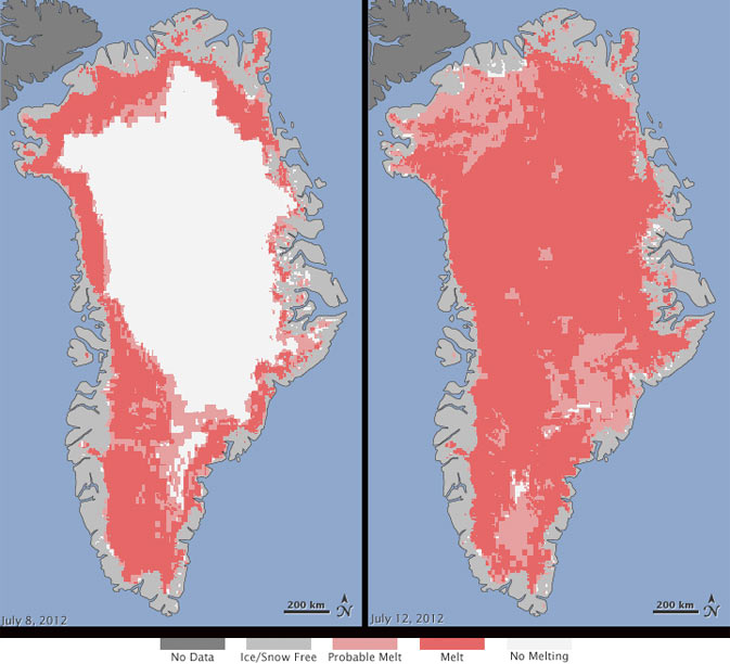
Greenland has had lots of surprises for researchers over the last decade. But until now these surprises have mostly been confined to its marine margins where glaciers are either in contact with the ocean or at lower altitude and thus more susceptible to seasonal swings in air temperatures. Above elevations called the “permanent or dry snow line”, summer melting is virtually non-existent. Large parts of Greenland’s interior are at elevations above 2 km, shielding it from seasonal melt—so much so that parts of Greenland’s interior are gaining mass as a consequence of annual snow accumulation without melt. This is offset by much larger mass loss at lower elevations near Greenland’s margins; as a whole, Greenland has been losing mass over the last few decades. In this context, the observations of the melting event on July 12—separately obtained from three satellites—are remarkable. They show that melting occurred over almost the entire ice sheet, even at the highest elevations. Such data have been collected by satellites on a daily basis since about 1979, and this event seems unprecedented. It is important to note though that week-to-week swings in surface temperatures can be very large (something we’re very familiar with here in Massachusetts), and while the July 11/12 temperatures were the largest recorded since 2005 at NOAA’s Greenland Summit Baseline Observatory (at 3220 m altitude), minimum temperatures just a week earlier (July 3) were among the lowest recorded since 2005. We thus have to be careful and ask what this short weather fluctuation implies for the long-term climate. Several studies suggest that Greenland-wide melt extent has doubled throughout the 2000′s, compared to that of the 1980′s, and that Greenland’s reflectivity (“albedo”) has diminished. Placing those apparent trends into context of natural climate swings, which occur over many decades is hampered by the lack of direct long-term observations.
Q2: What sort of effects would a large and sudden melt like this one have on the surrounding ocean and on sea level?
The combined Greenland-wide melting and increased glacier flow estimated from satellite data over the last decade indicates the Greenland is contributing approximately 0.4 to 0.7 millimeters of equivalent global sea level rise per year (mm/y), which is up to almost a quarter of the global mean. Greenland can lose its ice mass in two ways: (1) through melting and melt-water runoff into the ocean, or (2) through increased glacier flow speeds leading to increased calving at the front of outlet glaciers that spill into narrow deep fjords. At present the contribution from both effects is roughly equal. However, it is important to realize that melting from Greenland’s ice sheet interior is not thought to be an important contributor to loss of ice from Greenland as a whole: the melt we observe in the figure from areas that were white on July 8 is not likely to directly affect the ocean or sea level because this interior melt-water refreezes before it makes it in to the ocean.
Sea level change from Greenland mass loss is highly non-uniform. Recent research suggests that relative sea level would actually drop near Greenland and rise more strongly thousands of kilometers away, because of the reduced weight on the crust below the ice sheet, and the reduced gravitational pull of the smaller ice mass on the nearby waters. Another effect of Greenland mass loss is the freshening of the North Atlantic subpolar gyre. An open question is to what extent this added freshwater might reach the key convection regions in the subpolar gyre (the Labrador, Irminger and Greenland Seas) and have a significant impact on deep-water formation rates, or be trapped in the vigorous boundary currents. In any case, in competition with another freshwater source, current estimates suggest that freshening contributions from Greenland is small compared to freshwater export from the Arctic ocean into the North Atlantic.
Q3: Finally, is there anything you think is being overlooked in the coverage of this story? Anything about the cryosphere or this particular event that you think people should keep in mind as read and hear more about it?

You’ve asked me earlier what impact melting would have on the ocean circulation. Of equal importance is the extent to which changing ocean circulation has caused some of the observed changes in Greenland. Given that we see changes occurring preferentially at Greenland’s marine margins, and that land-terminating glaciers have not accelerated in the same way as fjord-terminating outlet glaciers, there is evidence that warmer ocean waters carrying heat to Greenland’s margins have increased submarine melting at the outlet glacier’s termini and played an important role in the observed glacier speed-ups. This view is consistent with observed shifts in the large-scale North Atlantic Ocean circulation over that period, and the advection of different, warmer, water masses to Greenland. Many more sustained observations in this harsh polar environment are required to untangle these complex physical processes. – Kenrick Vezina.


