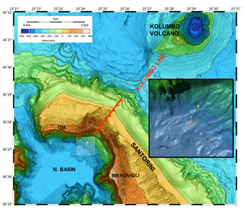
Topographic relief map of the northern Santorini volcanic field. The white star icon shows the location of the Kallisti Limnes CO2 pools. The onshore Kolumbo fault is indicated by a dashed red line, which along with the Kolumbo line, describes the northeast portion of the Christianna-Santorini-Kolumbo (CSK) tectonic line. The inset box shows a detailed view from the southwest of the caldera slope bathymetry around the study site; submersible vehicle track lines are indicated as red, orange, and yellow lines, corresponding to the first and second AUV dives, and the HOV dive, respectively. (Illustration courtesy of Camilli, et al)

