

Featured Stories | February 15, 2016
Chasing Whales
By Cassie Martin
This is the second article of a three-part series covering the Department of Earth, Atmospheric, and Planetary Sciences lectures on “Life in the Ocean.”
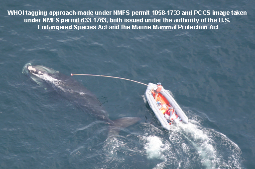
On a small orange dingy floating in the Atlantic Ocean, WHOI scientist Mark Baumgartner patiently watches the water’s surface for any sign of movement. Suddenly, the grey back of a North Atlantic right whale appears mere feet from the boat. Baumgartner springs into action, quickly tagging the creature with a monitoring device.
Baumgartner and colleagues use the devices and other instruments to track North Atlantic right whales as they hunt for food. Every day the whales must eat 1 to 2 billion copepods, microscopic marine crustaceans, to survive. Calorically, that’s equivalent to about 3000 McDonald’s Big Macs. “Understanding their foraging behavior—where they go, why they go there, and what they do there—is important for conservation,” Baumgartner said.
North Atlantic right whales are critically endangered. Hunted for the past 1000 years, only about 500 whales survive today. Although they received federal protection in the 1930s, why they haven’t rebounded like other protected whale species remains a mystery. Some researchers posit nutritional deficiency, toxin exposure, and/or inbreeding could be to blame. Fishing gear entanglement and ship strikes also threaten right whale survival.
Thanks to these tags and a variety of robotic instruments, however, researchers are using information about whale behavior to decrease ship strikes and other human-caused mortality events.
Once Baumgartner tagged the whale, the crew tracked its movements for up to three hours. They recorded where it dove, how long it was under, monitored close encounters with ships, and sampled properties of ocean water along the whale’s path. Previous monitoring efforts indicate that North Atlantic right whales forage at the surface and conduct deep exploratory dives, where they often find small clusters of copepods at mixed boundary layers. “It’s a remarkable coupling of top predator and physical oceanographic processes,” Baumgartner said. During springtime however, the whales scour the sea floor for prey.
Because whales feed in coastal regions, they are at risk for encounters with ships. One tagged whale Baumgartner followed came within 580 meters of a ship, but didn’t seem to notice it. “There’s some evidence that whales don’t hear ships until after they’ve passed,” he said. “Whales learn from negative experiences, and most whales that learn [from ship strikes] die.” Therefore, it’s up to us to protect them, he noted.
A few solutions include legislation to slow ships down and moving shipping lanes. For example, ocean circulation in Maine’s Bay of Fundy generates large swirling eddies rich in copepods. The Bay also happens to be a popular shipping route, with lanes cutting directly through the whales’ feeding grounds. Researchers used this data to negotiate with companies to move their lanes further east. The small change reduced hit probability by 80 percent.
Although tagging has given Baumgartner and colleagues valuable insights and resulted in positive changes, there’s still more to discover. That’s where autonomous robotic platforms come in. These devices can be used for weeks or months at a time, in remote systems such as the Arctic and off the coast of Alaska, and come in handy when weather conditions prevent observational monitoring.
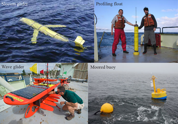
One instrument, called a slocum glider, is equipped with a digital acoustic monitoring device that records and processes audio in real time, as well as oceanographic sensors, a GPS receiver, and an Iridium satellite modem for two-way communication with land or ship-based computers. The glider moves through the water column using a buoyancy pump and wings that provide lift and passive forward momentum. Researchers use the glider to sample whale habitat and record marine mammal calls miles away.
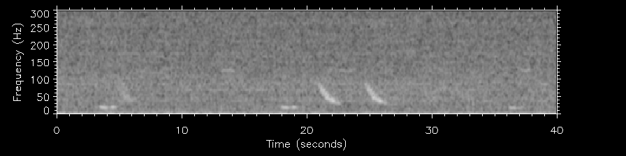
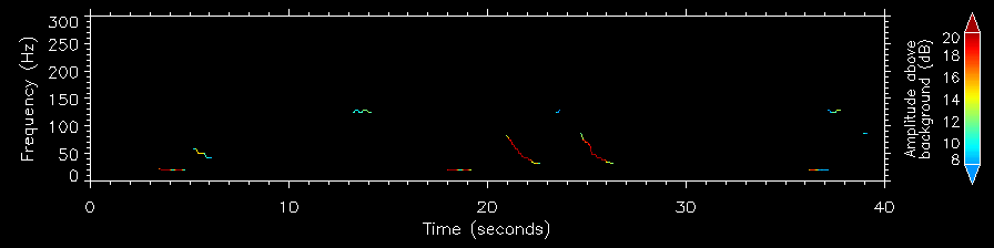
The following audio, provided by WHOI, captured North Atlantic right whale calls.
The recorded sounds result in a spectrogram—a method to visualize sound that describes its loudness and changing frequency, or pitch, over time. Researchers compare these “pitch tracks” to a library of known calls to identify the species responsible for them, and to get an estimate of how many are in a designated area.
Other platforms such as moored buoys, wave gliders, and profiling floats perform similar functions as the slocum glider, but are better suited for different purposes. For example, Baumgartner and colleagues used buoys off the coast of Martha’s Vineyard to monitor waters around the U.S. Coast Guard Gunnery Range. In the future, they hope to create an early warning system for beached whales by strategically placing buoys around the mouth of Cape Cod Bay—an area famous for marine mammal stranding. Similar projects are planned for New York Harbor and other coastal regions.

